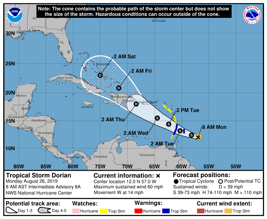
Dorian is currently east of the Lesser Antilles and heading west at 13 mph with 60 mph winds.
Dorian is an extremely compact system. This is due to its forming between two huge dry air masses that limited its growth. This is good and bad. Smaller systems can weaken quickly or strengthen just as quickly.
Dorian is expected to cross the Lessser Antilles as a tropical storm on Tuesday, and the National Hurricane Center has it strengthening into a hurricane (still on the fence with this) near the Dominican Republic, then weakening once over the islands into a tropical depression.
From there is the big question…. The kickers will be path and timing.
1st: If Dorian stays on its current path and passes over the Dominican Republic, it should weaken quickly. However, if it pulls north quicker and misses the islands, this will allow for further strengthening as it nears the Bahamas.
2nd: Dorian’s speed. There’s a front expected to push a lot of shear into the Gulf and Atlantic later this week, which would help weaken Dorian as it approaches.
My guess currently is that Dorian stays on course, hits the Lesser Antilles as a tropical storm, encounters shear/dry air, weakens some, crosses over the Dominican Republic, weakens more, exits near the Bahamas as a tropical depression or wave, strengthens “some,” and strikes the US coast as a small and weakened tropical depression or storm.
Lots to watch this week…
Everyone from Florida to North Carolina, and even from the Panhandle to Louisiana, should watch closely.


Chad Trosper is the AVP of Catastrophe Claims at Tower Hill Insurance. He has over 19 years of experience in the claims industry and a true passion for weather. Chad graduated from the University of Florida with a degree in Business and Sociology and also holds a master’s certification in Business Process Management from the University of San Francisco. Chad currently resides in Gainesville, Florida, with his wife and three children.