Like all my motivational books tell me, don’t focus on the future, focus on the present. So before we get into next week, let’s look at what we have now.
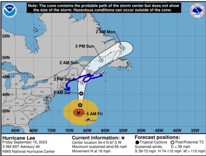
Lee has made up his mind and is headed to Canada(ish). Currently leveled out at 85mph winds and headed north at 16mph. Should be arriving to make landfall this weekend. Looks like it will miss most of the US, but could bring some winds and big rains to the northeast.
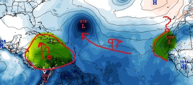
We also have I97 with a 90% chance. Again, this one should strengthen based on modeling and become Nigel. As for the track, well most have it resemble Lee’s track but pulling north a little quicker for now. But we will be watching for sure.
 Okay, I did it. Now let’s look into the future.
We have a new blob at 20%. This one is not getting a lot of love from the models for now. They do show potential for this to push moisture into the Caribbean though that could affect next week’s forecast, but for now, we don’t expect much from this little yellow blob.
So next week will start to get interesting. We could see two areas form and put us on our tippy toes.
First, we could see a decent wave come off Africa that could push west and develop. Models are all pinging this wave expected early next week. They also support development. So we will be watching for this one for sure.
Second, we could see moisture build in the Caribbean next week. This moisture will have the potential to develop and push up into the Gulf/Atlantic. Models off and on with this, but MJO also supports energy here. So could we see another September Caribbean Creeper push up? I think we have a good chance, so make sure you’re watching the Caribbean closely folks. September is the peak and as expected the tropics are right on time with momentum.
**Remember that October is the season of Home Grown Caribbean Creepers (just noticed that this slogan fits perfectly for Halloween), so we may not be getting much of a break for the next few months.
Stay tuned folks.

Chad Trosper is the AVP of Catastrophe Claims at Tower Hill Insurance. He has over 19 years of experience in the claims industry and a true passion for weather. Chad graduated from the University of Florida with a degree in Business and Sociology and also holds a master’s certification in Business Process Management from the University of San Francisco. Chad currently resides in Gainesville, Florida, with his wife and three children.